Geography and Geology
Physically, the peninsula comprises two plains separated by the Niagara Escarpment. The Ontario Plain has fertile, sandy soils and a favourable climate. It contains the Niagara Fruit Belt. Much of Canada’s tender fruits, such as peaches, pears and plums, are grown here. The region is also home to many vineyards. The wooded slopes of the escarpment, an abrupt rise of some 60 m, are etched deeply by gorges. These gorges have falls at their heads, most notably at Niagara Falls, and are quarried for limestone. The Erie Plain, with bedrock closer to the surface, is less productive than its northern counterpart. The soils are poorly drained clay. The climate is wetter, with shorter frost-free periods. The Onondaga Escarpment, inland from Lake Erie, is quarried for limestone.
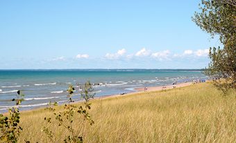
Subregions in the peninsula provide a rich variation of detail: shoreline bluffs along Lake Ontario, with ponded river estuaries behind sandbars; the shoreline of glacial Lake Iroquois across the Ontario Plain; the Short Hills embayment in the escarpment, with steep-sided slopes; a glacial kame of sand deposits at Fonthill, the highest point of the peninsula; the buried St. Davids Gorge, the plugged channel of an ancestral Niagara River; marsh areas, including peat bogs, on the southern plain; the slender Onondaga Escarpment; and limestone headlands alternating with sandy bays along Lake Erie, contrasting with the eroding clay and sand bluffs along Lake Ontario.
Indigenous Peoples
The Iroquoian-speaking Neutral lived throughout the Niagara Peninsula, between the Grand and Niagara rivers. They were called Neutral by the French, who observed that the tribe remained neutral in most conflicts between the Huron-Wendat and the Haudenosaunee. In addition to hunting and fishing, the Neutral grew squash, beans and corn, and their villages included longhouses.
In 1647, several Neutral villages were conquered by the Seneca from the east side of the Niagara River. Later, in the early 1650s, additional villages were destroyed by the Haudenosaunee. These attacks, combined with the smallpox epidemics of 1638–40, meant the Neutral population largely ceased to exist. They were last mentioned in the writing of French explorers in 1671. The Haudenosaunee, however, continued to live in the region as the French, British and Americans fought for control. By the early 1700s they had been joined by the Anishinaabeg, in particular the Mississauga, who were migrating westward from the continent’s northeast coast. Today, many Haudenosaunee and Mississauga remain in the Niagara Peninsula area, both on the Six Nations of the Grand River reserve and in other communities.
European Settlement
Permanent European settlement began during the 1780s with the influx of Loyalists. Officials temporarily established Niagara-on-the-Lake as the first capital of Upper Canada. Queenston and Chippawa developed as portage terminals. At the same time, Fort George, Fort Mississauga and Fort Erie developed as garrisons commanding entry to the Niagara River. Immigrants first settled the Niagara River frontage and the Ontario Plain, then the Erie Plain. Townships, surveyed with 40 hectare lots, had a road in front of each concession and between every other lot. Mills developed mostly where rivers crossing the Niagara Escarpment and the Ontario Plain could be diverted for water power. Small settlements arose here and at several “corners” accessible from nearby communities.
The War of 1812 disrupted the expanding economy. William Lyon Mackenzie and some of his supporters crossed the border during the Rebellions of 1837. Between 1866 and 1871, Fenians launched raids from the American side of the peninsula. Closer contact between Canada and the United States prevailed with interlinking rail and highway bridges.
Welland Canal
The Niagara River could not be used for through navigation. Because of this, settlers built the Welland Canal. It provided through transport by water between the continental interior and Lake Ontario. First opened in 1829 but continually enlarged, the canal had water power available at every lock, where streams were crossed, and from hydraulic raceways. The Welland Canal prompted a line of new settlement on the peninsula: St. Catharines became an industrial town; Port Dalhousie and Port Colborne grew as ports; and Thorold and Welland were founded, together with Port Robinson and Allanburg on the main canal and Wainfleet and Dunnville on the feeder canal. Niagara-on-the-Lake lost its premier position, and the county functions were transferred to Welland and subsequently St. Catharines.
Railways
The development of railways strengthened existing settlements. Routes were constructed during the 1850s along the two lakeshores, and the Niagara River and the Welland Canal were augmented by two southern routes during the 1870s. A transverse Hamilton-Buffalo line was added in the 1890s. Settlement expanded at border crossing points, especially Clifton (now Niagara Falls) at the Suspension Bridge and Victoria (Bridgeburg, now Fort Erie) at the International Bridge. Welland, at the hub of the peninsula, expanded as did Merritton. Railways also encouraged the emergence of fruit farming, which replaced wheat and mixed farming north of the Niagara Escarpment; cottage and recreational development along the shoreline of Lake Erie; and tourism at Niagara Falls. St. Catharines became a spa, and religious campgrounds were introduced at Niagara-on-the-Lake, Niagara Falls, Crystal Beach and Grimsby Beach.
Hydroelectricity and Transportation
Infrastructure on the Niagara Peninsula was again strengthened through hydroelectric developments at Niagara Falls and DeCew Falls (St. Catharines) from the Welland Canal. As generating stations, storage reservoirs and power transmission lines were added to the landscape, towns obtained a new impetus for expansion. Major industries developed, especially along the Welland Canal in St. Catharines, Thorold, Welland and Port Colborne, and at Niagara Falls and Chippawa on the Niagara River.
An extensive interurban streetcar network connected the towns until the automobile became dominant. New highway bridges were constructed across the Niagara River and the Welland Canal. Major roads inland from the border crossing points were improved, and the Queen Elizabeth Way opened in 1939.
During the postwar period, urban sprawl into the peninsula from the west presented problems. For example, the annual loss of agricultural land on the most productive soils in Canada was severe. Suburban shopping centres weakened the retailing strength of historic urban centres. In addition, the Niagara Escarpment as a vital scenic landscape was threatened by linear development. Conservation, urban quality and respect for the environment became major issues.
Population and Economy
The Niagara Regional Municipality, which makes up the bulk of the Niagara Peninsula, is home to 447,888 people, according to the 2016 census. Its principal city is St. Catharines. Niagara Falls and Welland are its other major centres.
Manufacturing has declined drastically while service activities, including medicine, education and government, have expanded greatly. In the agricultural industry, there are many established and new estate wineries. Vineyards, peach and cherry orchards are supplemented by greenhouses growing flowers, cucumbers and tomatoes. Livestock output is headed by poultry.
Tourism is an expanding industry, especially gambling in Niagara Falls, heritage tourism in Niagara-on-the-Lake and a growing agritourism industry associated with the peninsula’s wineries. Each of the peninsula’s major centres also has its own tourist draws.

 Share on Facebook
 Share on X
 Share by Email
 Share on Google Classroom


