With the 1783 Treaty of Paris diplomats attempted to settle the many disputes over the boundary, but they had little knowledge of the geography or history of the lands under discussion. The document they produced was vague and unrealistic, with an airy
reference to a latitudinal connection between Lake of the Woods and the Mighty Mississippi. They determined the boundary as a line from the upper corner of Lake of the Woods due west to the Mississippi River. You don''t have to be a geographer to realize
that a person could get lost seeking that connection.
On October 20, 1818 a British-American convention clarified the western border between Canada and the United States "as a line from the farthest northwest part of Lake of the Woods to the 49th parallel and thence west to the Rocky Mountains. That same year both Britain and the U.S. registered joint claims over the Oregon Territory, the region west of the Rockies and between 42o N and 54o 40' N. The conflicting claims over Oregon became an explosive issue in the 1840s as the Americans coveted a boundary all the way up to Russian Alaska. The British saw the Columbia River as the appropriate border.
In 1844 James Knox Polk used the boundary dispute as his campaign platform in the presidential election. His slogan was "54-40 or fight! and he promised to go to war over the issue. Polk won the election but decided that he would rather negotiate than fight and the British were happy to comply. The Oregon Treaty of 1846 (in American history called the Treaty of Washington) extended the 49th parallel to the Pacific. (The little island of San Juan lay in an ambiguous area and the Americans staked their claim by landing troops there in 1859. The matter was referred to the German emperor Wilhelm I in 1872 and he decided in favour of the U.S.)
Determining a boundary on a map is simple compared to actually marking it on the land. Both nations appointed boundary commissions to map the frontier, with each team working separately. Lt-Col John Hawkins headed the British Commission and Archibald Campbell was his American counterpart. There was friction between the two men, who disagreed about how to proceed. Hawkins argued that boundary markers should be placed every mile "in open ground. The Americans refused to bear their share of the cost but did agree to place markers wherever the 49th parallel crossed "streams of any size, permanent trails, or any striking natural features of the country.

|
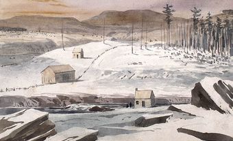
| Cutting on the 49th parallel, on the right bank of the Moyie River, looking west, 1860 (courtesy North American Boundary Commission). |
Added to the tension between the two men were disputes between their governments, the occasional military fracas, a series of aboriginal wars, hostility between the Americans and the British commissioners, rugged terrain and variable weather. It took four backbreaking years for Hawkins' men to locate and map the boundary determined by the Oregon Treaty. It took another half-century before the Hawkins-Campbell survey was officially recognized.
When the British and Americans met to prepare official maps of the survey several years later, they discovered, not surprisingly, some discrepancies. The method of reconciliation was surprising -they merely split the difference, drawing a mean line between the originals. It seemed a good compromise at the time, but it only confused matters in determining titles and jurisdictions when settlers moved into boundary areas and found two and sometimes three lines cut through the woods and multiple boundary markers. The authorities needed the survey documents to rectify the maps but the documents had disappeared- from both commissions!
The Americans had postponed publishing their reports in the need for economy after the Civil War. The British reports were found by Otto Klotz, of the Canadian astronomical service, at the Royal Observatory at Greenwich in 1898, when he glimpsed some boxes marked "B.N.A. and had the janitor retrieve them.
Finally, both governments undertook a new survey between 1901 and 1907, in which new lines were cut, old ones cleared and missing markers replaced. Remarkably, few corrections had to be made to Hawkins' and Campbell's original careful surveys.
This episode looks at the thing that literally defines Canada - the border. What happened to First Nations when the border was drawn right through their land? And as American "draft dodgers" came north, why did thousands of Canadians volunteer to fight for the U.S. during the war in Vietnam?
Note: The Secret Life of Canada is hosted and written by Falen Johnson and Leah Simone Bowen and is a CBC original podcast independent of The Canadian Encyclopedia.

 Share on Facebook
 Share on X
 Share by Email
 Share on Google Classroom

