Bruce Peninsula
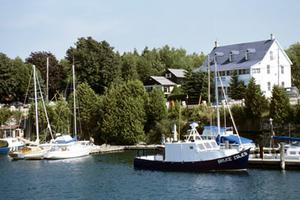
Bruce Peninsula, 100 km long, 38 km wide at base, juts northwest from OWEN SOUND to Tobermory, thus forming GEORGIAN BAY in Lake HURON, Ontario. Composed of NIAGARA ESCARPMENT strata, it has a gentle tilt from the cliffs on Georgian Bay to the flat sand and clay plains on Lake Huron's shore.
Owen Sound and Colpoys Bay form fjordlike harbours on Georgian Bay. Cape Croker, projecting 10 km into the bay, is an Ojibwa reserve. Adjacent Hope Bay is famous for its sheer limestone cliffs and sandy beach. At Lion's Head a jagged rock formation 51 m high gives the site its name. The BRUCE TRAIL follows the rugged wilderness of the Georgian Bay side of the peninsula.
Called "the North American rendezvous of plants," the Bruce is a paradise for botanists, containing northern, transitional and southern tree species, approximately 49 orchid species and 30 species of ferns.
Preservation
The northwest tip and the Georgian Bay side of the peninsula have been protected by the FATHOM FIVE NATIONAL MARINE PARK, BRUCE PENINSULA NATIONAL PARK, 4 provincial parks and 7 other protected areas. The Niagara escarpment which runs the length of the peninsula has been designated a United Nations BIOSPHERE RESERVE.

 Share on Facebook
 Share on X
 Share by Email
 Share on Google Classroom


