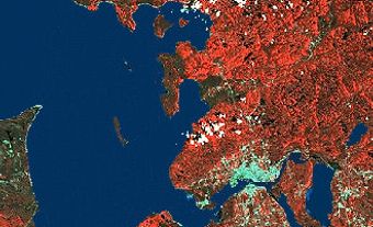
South Nahanni River, 563 km long, flows southeast out of the Ragged Range of the Selwyn Mountains, cuts across successive spines of the Mackenzie Mountains and empties into the Liard River. In 1972 the federal government formed Nahanni National Park to enclose the lower two-thirds of the South Nahanni and the lower half of its main tributary, the Flat River. The area's geological diversity is unexcelled: hot springs, glaciers, karst landscape with bottomless sinkhole lakes, marshes, desertscapes, tundra plateaus, towering hoodoos and thick forests. Through it plunges the river called Nahadeh by the Slavey, "powerful river," with its whirlpool rapids, waterfalls and the three most spectacular river canyons in Canada.
The name "Nahanni" is Athapaskan for "people of the west," referring to the Nahani. The gorges of Five Mile Canyon, Figure Eight Canyon and Hell's Gate have been cut by the river through the spine of the Mackenzie Mountains and remain sharp and narrow because this is one of the few spots in Canada that escaped the gouging of the last continental ice sheets.
About 150 km from the confluence with the Liard, the river constricts to one-fifth its previous width, forms a jet called the Chutes and flares out into a waterfall - almost half again as high as Niagara - called Virginia Falls for the daughter of Fenley Hunter, who first measured it in 1928. Nahanni Butte, an Indigenous village, is practically the only settlement in the area. The first white people to see the river were the passing traders on their way to the Klondike.

 Share on Facebook
 Share on X
 Share by Email
 Share on Google Classroom


