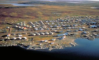
Pangnirtung, Nunavut, incorporated as a hamlet in 1972, population 1425 (2011c), 1325 (2006c). The Hamlet of Pangnirtung is located on the southeast shore of Pangnirtung Fjord, on the south shore of Baffin Island's Cumberland Sound, 297 km northeast of Iqaluit. The name derives from an Inuit word said to mean "place of the bull caribou."
The area, which is near the edge of a tundra flat between the base of glaciated mountains and the sea, was first visited by John Davis in 1585. By 1840 it had become one of the arctic points where whaling ships gathered most often. Some local Angmarlik Inuit became well-known whaleboat skippers. Several local Inuit provided invaluable guidance to explorers such as Charles F. Hall (c 1860).
During 1882-83 Cumberland Sound was the base camp of German scientists participating in the International Polar Year. By about 1910 whaling was in decline, but interest in white fox took up the slack; the Hudson's Bay Company built a trading post at Pangnirtung in 1921. The RCMP post was established in 1923. In 1968 the local Inuit formed a co-operative to promote soapstone and whalebone carvings.
Today the community is known for its artworks, particularly the world-famous woven tapestries made by local Inuit artists. It is also the access point to Auyuittuq National Park (created 1972).
See also Inuit Art.

 Share on Facebook
 Share on X
 Share by Email
 Share on Google Classroom

