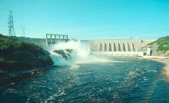
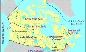
Smallwood Reservoir, 6527 km2, elev 472 m, tenth-largest freshwater body in Canada, is situated on the remote Labrador Plateau, near the Québec border. It was created in the 1960s for hydroelectric-power production by damming the CHURCHILL R at CHURCHILL FALLS and diking other rivers. The water level varies by 8.7 m, giving a usable water reserve of 28 billion m3.
-
- MLA 8TH EDITION
- Maccallum, Ian. "Smallwood Reservoir". The Canadian Encyclopedia, 04 March 2015, Historica Canada. www.thecanadianencyclopedia.ca/en/article/smallwood-reservoir. Accessed 04 December 2024.
- Copy
-
- APA 6TH EDITION
- Maccallum, I. (2015). Smallwood Reservoir. In The Canadian Encyclopedia. Retrieved from https://www.thecanadianencyclopedia.ca/en/article/smallwood-reservoir
- Copy
-
- CHICAGO 17TH EDITION
- Maccallum, Ian. "Smallwood Reservoir." The Canadian Encyclopedia. Historica Canada. Article published February 07, 2006; Last Edited March 04, 2015.
- Copy
-
- TURABIAN 8TH EDITION
- The Canadian Encyclopedia, s.v. "Smallwood Reservoir," by Ian Maccallum, Accessed December 04, 2024, https://www.thecanadianencyclopedia.ca/en/article/smallwood-reservoir
- Copy
Thank you for your submission
Our team will be reviewing your submission
and get back to you with any further questions.
Thanks for contributing to The Canadian Encyclopedia.
CloseArticle
Smallwood Reservoir
Article by Ian Maccallum
Published Online February 7, 2006
Last Edited March 4, 2015

 Share on Facebook
 Share on X
 Share by Email
 Share on Google Classroom


